RSS

Tag Archives: research

Visualizing Global Risks 2013

Visualizing Global Risks 2013

A year ago we looked at Global Trends 2025, a 2008 report by the National Intelligence Commission. The 120 page document made surprisingly little use of data visualization, given the well-funded and otherwise very detailed report.

By contrast, at the recent World Economic Forum 2013 in Davos, the Risk Response Network published the eighth edition of its annual Global Risks 2013 report. Its focus on national resilience fits well into the “Resilient Dynamism” theme of this year’s WEF Davos. Here is a good 2 min synopsis of the Global Risks 2013 report.

We will look at the abundant use of data visualization in this work, which is published in print as an 80-page .pdf file. The report links back to the companion website, which offers lots of additional materials (such as videos) and a much more interactive experience (such as the Data Explorer). The website is a great example of the benefits of modern layout, with annotations, footnotes, references and figures broken out in a second column next to the main text.

RiskCategories

One of the main ways to understand risks is to quantify it in two dimensions, namely its likelihood and its impact, say on a scale from 1 (min) to 5 (max). Each risk can then be visualized by its position in the square spanned by those two dimensions. Often risk mitigation is prioritized by the product of these two factors. In other words, the further right and/or top a risk, the more important it becomes to prepare for or mitigate it.

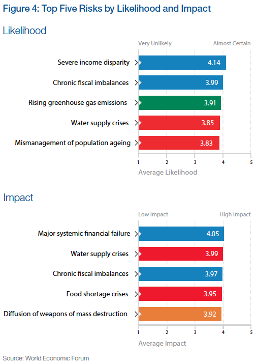
This work is based on a comprehensive survey of more than 1000 experts worldwide on a range of 50 risks across 5 broad categories. Each of these categories is assigned a color, which is then used consistently throughout the report. Based on the survey results the report uses some basic visualizations, such as a list of the top 5 risks by likelihood and impact, respectively.

Source for all figures: World Economic Forum (except where noted otherwise)

Source for all figures: World Economic Forum (except where noted otherwise)

When comparing the position of a particular risk in the quadrant with the previous year(s), one can highlight the change. This is similar to what we have done with highlighting position changes in Gartner’s Magic Quadrant on Business Intelligence. Applied to this risk quadrant the report includes a picture like this for each of the five risk categories:

EconomicRisksChange

This vector field shows at a glance how many and which risks have grown by how much. The fact that a majority of the 50 risks show sizable moves to the top right is of course a big concern. Note that the graphic does not show the entire square from 1 through 5, just a sub-section, essentially the top-right quadrant.

On a more methodical note, I am not sure whether surveys are a very reliable instrument in identifying the actual risks, probably more the perception of risks. It is quite possible that some unknown risks – such as the unprecedented terrorist attacks in the US on 9/11 – outweigh the ones covered here. That said, the wisdom of crowds tends to be a good instrument at identifying the perception of known risks.

Note the “Severe income disparity” risk near the top-right, related to the phenomenon of economic inequality we have looked at in various posts on this Blog (Inequality and the World Economy or Underestimating Wealth Inequality).

A tabular form of showing the top 5 risks over the last seven consecutive years is given as well: (Click on chart for full-resolution image)

Top5RisksChanges

This format provides a feel for the dominance of risk categories (frequency of colors, such as impact of blue = economic risks) and for year over year changes (little change 2012 to 2013). The 2011 column on likelihood marks a bit of an outlier with four of five risks being green (= environmental) after four years without any green risk in the Top 5. I suspect that this was the result of the broad global media coverage after the April 2011 earthquake off the coast of Japan, with the resulting tsunami inflicting massive damage and loss of lives as well as the Fukushima nuclear reactor catastrophe. Again, this reinforces my belief that we are looking at perception of risk rather than actual risk.

Another aggregate visualization of the risk landscape comes in the form of a matrix of heat-maps indicating the distribution of survey responses.

SurveyResponseDistribution

The darker the color of the tile, the more often that particular likelihood/impact combination was chosen in the survey. There is a clear positive correlation between likelihood and impact as perceived by the majority of the experts in the survey. From the report:

Still it is interesting to observe how for some risks, particularly technological risks such as critical systems failure, the answers are more distributed than for others – chronic fiscal imbalances are a good example. It appears that there is less agreement among experts over the former and stronger consensus over the latter.

The report includes many more variations on this theme, such as scatterplots of risk perception by year, gender, age, region of residence etc. Another line of analysis concerns the center of gravity, i.e. the degree of systemic connectivity between risks within each category, as well as the movement of those centers year over year.

Another set of interesting visualizations comes from the connections between risks. From the report:

Top5Connections

Top10ConnectedRisks

Finally, the survey asked respondents to choose pairs of risks which they think are strongly interconnected. They were asked to pick a minimum of three and maximum of ten such connections.

Putting together all chosen paired connections from all respondents leads to the network diagram presented in Figure 37 – the Risk Interconnection Map. The diagram is constructed so that more connected risks are closer to the centre, while weakly connected risks are further out. The strength of the line depends on how many people had selected that particular combination.

529 different connections were identified by survey respondents out of the theoretical maximum of 1,225 combinations possible. The top selected combinations are shown in Figure 38.

It is also interesting to see which are the most connected risks (see Figure 39) and where the five centres of gravity are located in the network (see Figure 40).

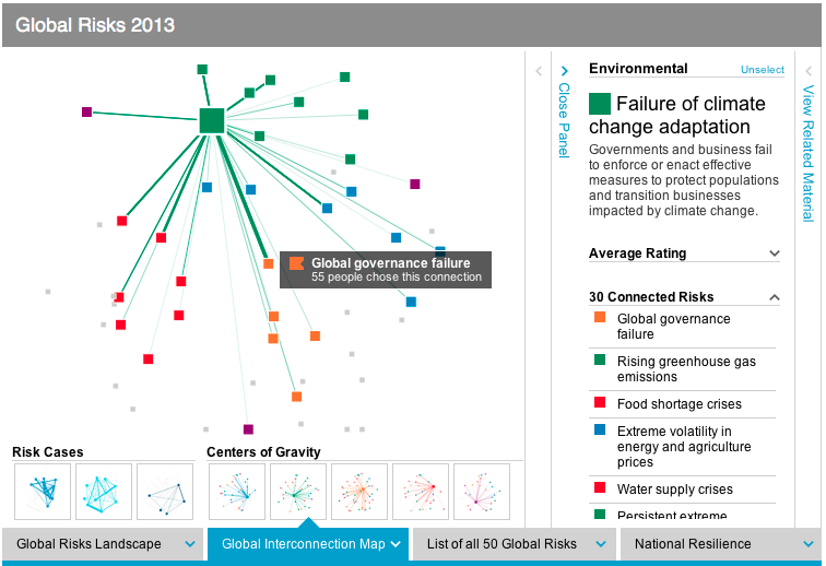
One such center of gravity graph (for geopolitical risks) is shown here:RiskInterconnections

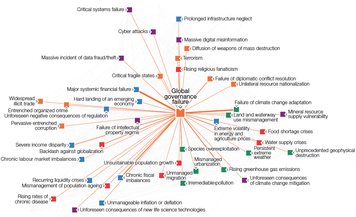
The Risk Interconnection Map puts it all together:

RiskInterconnectionMap

Such fairly complex graphs are more intuitively understood in an interactive format. This is where the online Data Explorer comes in. It is a very powerful instrument to better understand the risk landscape, risk interconnections, risk rankings and national resilience analysis. There are panels to filter, the graphs respond to mouse-overs with more detail and there are ample details to explain the ideas behind the graphs.

DataExplorer

There are many more aspects to this report, including the appendices with survey results, national resilience rankings, three global risk scenarios, five X-factor risks, etc. For our purposes here suffice it to say that the use of advanced data visualizations together with online exploration of the data set is a welcome evolution of such public reports. A decade ago no amount of money could have bought the kind of interactive report and analysis tools which are now available for free. The clarity of the risk landscape picture that’s emerging is exciting, although the landscape itself is rather concerning.

 
1 Comment

Posted by on January 31, 2013 in Industrial, Socioeconomic


Tags: , , , , , , ,

Scientific Research Trends

Scientific Research Trends

The site worldmapper.org has published hundreds of cartogram world maps; cartograms are geographic maps with the size of the depicted areas proportional to a specified metric. This leads to the distorted versions of countries or entire continents relative to the original geographical size we are used to. (We recently looked at cartograms of world mobile phone adoption here.)

One interesting set of cartograms from worldmapper.org relates to scientific research. The first shows the amounts of science papers (as of 2001) authored by people living in the respective areas:

Science Research (Number of research articles, Source: Worldmapper.org)

Another shows the growth in the above number between 1990 and 2001:

Science Growth (Change in Number of research articles, Source: Worldmapper.org)

From worldmapper.org:

This map shows the growth in scientific research of territories between 1990 and 2001. If there was no increase in scientific publications that territory has no area on the map.

In 1990, 80 scientific papers were published per million people living in the world, this increased to 106 per million by 2001. This increase was experienced primarily in territories with strong existing scientific research. However, the United States, with the highest total publications in 2001, experienced a smaller increase since 1990 than that in Japan, China, Germany and the Republic of Korea. Singapore had the greatest per person increase in scientific publications.

It is worth noting that the trends depicted are based on data one decade old. It is likely, however, that those trends have continued over the past decade, something which Neil deGrasse Tyson points out with concern regarding the relative decline of scientific research in America in this YouTube video:

Another point Tyson emphasizes is the near total absence of scientific research from the entire continent of Africa as evidenced by the disappearance of the continent on the cartogram. With about a billion people living there it is one of the stark visualizations of the challenges they face to escape from their poverty trap.

 
Leave a comment

Posted by on January 3, 2012 in Scientific, Socioeconomic


Tags: , ,

The Observatory of Economic Complexity

The Observatory of Economic Complexity

In this second part we will look at the online interactive visualizations as a companion to the first part’s Atlas of Economic Complexity. It’s interesting that the authors chose the title “Observatory”, as if to convey that with a good (perhaps optical) instrument you can reveal otherwise hidden structure. To repeat one of the fundamental tenets of this Blog: Interactive graphics allow the user to explore data sets and thus to develop a better understanding of the structure and potentially create otherwise inaccessible insights. This is a good example.

The two basic dimensions for exploration of trade data are products and countries. The most recent world trade data is from 2009 and it ranges back between 20 to 50 years (varying by country). I worked with three types of charts: TreeMaps, Stacked Area Charts, and the Product Space network diagram. Let’s start with Germany’s Exports in 2009:

Hovering the cursor over a node highlights it’s details, here “Printing Presses”, a product type where Germany enjoys a high degree of Revealed Comparative Advantage (RCA). (For details on RCA or any other aspects of the product space concept and network diagram, please see the previous post on the Atlas of Economic Complexity.) We can now explore which other countries are exporting printing presses:

While Germany clearly dominates this world market with 55% at $2.7b in 2009 with RCA = 5.6, the time slider at the bottom (with data since 1975) reveals that it has actually held an even bigger lead for most of the last 35 years. For example, with it’s exports in Printing Presses Germany commanded 72% at 3.7b in 2001 with RCA = 6.3 From the timeline one can also see how the United States captured about 20% of this (then much smaller) market for a brief period between 1979 and 1983. During this time its RCA for Printing Presses was just a bit above 1.0 – which shows as a black square in the Product Space – but the United States has since lost this advantage and not seen any significant exports in this product type. Printing Presses being a fairly complex product, only a handful of countries are exporting them, almost all of them European and Japan. There might be an interesting correlation between complexity and inequality, as the capabilities for the production of complex products tend to cluster in a few countries worldwide which then dominate world exports accordingly.

Another powerful instrument are Stacked Area Charts. Here you can see how a country’s Imports or Exports evolve over time, either in terms of absolute value or relative share of product types. For example, let’s look at the last 30 years (1978-2008) of Export data for the United States:

This GIF file (click if not animated) shows several frames. In Value display style one can see the absolute size and how Exports grew roughly 10-fold from about $100b to $1t over the course of those 30 years. The Share display style focuses on relative size, with all Exports always representing 100%. In the Observatory one can hover over any product type and thus highlight that color band to see the evolution of this product type’s Exports over time. In the highlighted example here, we can see how ‘Cereal and Vegetable Oil’ (yellow band) shrank from around 15% in the late seventies to around 5% since the late nineties. ‘Chemicals and Health Related Products’ (purple band) has remained more or less constant around a 10% Export share. ‘Electronics’ bloomed in the mid eighties from less than 10% to 15-20% and stayed on the high end of that range until around the year 2000 before shrinking in the last decade down to about 10%.

As a final example, look at the relative size of imports of the United States over the last 40 years, (1968 – 2008, sorted by final value):

The biggest category is crude petroleum products at the bottom. During the two oil shocks in the seventies the percentage peaked near 30% of all imports. Then it went down and stayed below 10% between 1985 – 2005. Since then it’s percentage has been steadily rising and reached about 15% again. (The data isn’t enough up-to-date to illustrate the impact of the 2008 recession.) Such high expenses are crowding out other categories. When the consumer pays more at the pump there is less to spend for other product types. Another interesting aspect of this last chart is that the bottom two bands represent opposite ends of the product complexity spectrum: Petroleum (brown) on the low end, cars (blue) on the high end.

As always, the real power of interactive visualizations comes from interacting with them. So I encourage you to explore these data at the Observatory of Economic Complexity.

Caveats: I noticed a couple of minor areas which seem to be either incomplete, counter-intuitive, poor design choices or simply implementation bugs. To start, there is no help or documentation of the visualization tool itself. Many of the diagram types on the left are grayed out and it is not always apparent what selection of products, countries or chart type will enable certain subselections. For example, there is a chart type “Predictive Tools” with two subtypes “Density Bars” and “Stepping Stone” that always seem to be grayed out? The same applies to Maps (presumably geographic maps) – all subtypes are grayed out. Perhaps I am missing something – would appreciate any comments if that’s the case.

In the TreeMaps for import and export one can not see the overall value of the overall trade (top-level rectangle) or any of the categories (second-level rectangles). Only the tooltips will show the value of a specific product type or country (third-level rectangle). The color legend is designed for the product space and designates the 34 communities of product types. When you hover the mouse over one product type, say garments (in green), then all imports / exports other than that product type are grayed out. When you show a product import / export chart, however, those same colors are used to designate groups of countries with color indicating continents (blue for Europe, red for the Americas, green for Asia etc.). Yet when you hover over the product icon in the legend (say garment), then only it’s corresponding color’s countries remains highlighted, which doesn’t make sense and can be misleading.
When you play the timeline in a TreeMap, the frequent change in layout can be confusing. A change from one year to the next played back and forth slowly or multiple times can be instructive, but a quick series of too many changes (particularly without seeing the labels) is just confusing.

In the stacked area charts when you click on Build Visualization it always comes up in “Value” style, even if “Share” is selected. To get to the Share style, you have to select Value and then Share again.

TreeMaps and Stacked Area Charts critically depend on the availability of data for all products / countries displayed. For years before 1990 there appear to be pockets of only sparsely available data, which then falsely suggests world market dominance of those products or countries. For example, the TreeMap for Imports in Printing Presses for 1983 shows the United States with 97% taking practically the entire market. In 1984, it’s share shrinks to a more balanced 28% despite growing very rapidly; simply because data for other countries from Europe, Asia etc. seems to not be available prior to 1984. In such cases it would have been better to show the rest as gray rectangle instead of leaving it out (if world import data are available) or just not display any chart for years with grossly incomplete data.

Navigation is somewhat limited. For example, looking at a country chart (say United Kingdom), it would be great to click on any product type (say crude petroleum) and get to a corresponding Stacked Area Chart diagram for that product type. One can do so using the drop-down boxes on the right, but that’s less intuitive.

There are two export formats (PDF and SVG). The vector graphics is a good choice since the fonts can be rendered fine even in the small print. I obtained poor results with PDF, however, as often the texts in TreeMaps were not aligned properly and printed on top of one another.

None of the above is a serious problem or even a showstopper. It would be great, however, if there was a feedback link to provide such info back to the authors and help improve the utility of this observatory.

 
1 Comment

Posted by on November 14, 2011 in Industrial, Scientific, Socioeconomic


Tags: , ,

The Atlas of Economic Complexity

The Atlas of Economic Complexity

Here is a recipe: Bring together renowned faculties like the MIT Media Lab and Harvard’s Center for International Development. Combine novel ideas about economic measures with years of solid economic research. Leverage large sets of world trade data. Apply network graph theory algorithms and throw in some stunning visualizations. The result: The Atlas of Economic Complexity, a revolutionary way of looking at world trade and understanding variations in countries paths to prosperity.

The main authors are Professors Ricardo Hausmann from Harvard and Cesar Hidalgo from MIT (whose graphic work on Human Development Indices we have reviewed here). The underlying research began in 2006 with the idea of the product space which was published in Science in 2007. This post is the first in a two-part series covering both the atlas (theory, documentation) as well as the observatory (interactive visualization) of economic complexity. This research is an excellent example of how the availability of large amounts of data, computing power and free distribution via the Internet enable entirely new ways of looking at and understanding our world.

The Atlas of Economic Complexity is rooted in a set of ideas about how to measure economies based not just on the quantity of products traded, but also on the required knowledge and capabilities to produce them. World Trade data allows us to measure import and export product quantities directly, leading to indicators such as GDP, GDP per capita, Growth of GDP etc. However, we have no direct way to measure the knowledge required to create the products. A central observation is that complex products require more capabilities to produce, and countries who manufacture more complex products must possess more of these capabilities than others who do not. From Part I of the Atlas:

Ultimately, the complexity of an economy is related to the multiplicity of useful knowledge embedded in it. For a complex society to exist, and to sustain itself, people who know about design, marketing, finance, technology, human resource management, operations and trade law must be able to interact and combine their knowledge to make products. These same products cannot be made in societies that are missing parts of this capability set. Economic complexity, therefore, is expressed in the composition of a country’s productive output and reflects the structures that emerge to hold and combine knowledge.

Can we analyze world trade data in such a way as to tease out relative rankings in terms of these capabilities?

To this end, the authors start by looking at the trade web of countries exporting products. For each country, they examine how many different products it is capable of producing; this is called the country’s Diversity. And for each product, they look at how many countries can produce it; this is called the product’s Ubiquity. Based on these two measures, Diversity and Ubiquity, they introduce two complexity measures: The Economic Complexity Index (ECI, for a country) and the Product Complexity Index (PCI, for a product).

The mechanics of how these measures are calculated are somewhat sophisticated. Yet they encode some straightforward observations and are explained with some examples:

Take medical imaging devices. These machines are made in few places, but the countries that are able to make them, such as the United States or Germany, also export a large number of other products. We can infer that medical imaging devices are complex because few countries make them, and those that do tend to be diverse. By contrast, wood logs are exported by most countries, indicating that many countries have the knowledge required to export them. Now consider the case of raw diamonds. These products are extracted in very few places, making their ubiquity quite low. But is this a reflection of the high knowledge-intensity of raw diamonds? Of course not. If raw diamonds were complex, the countries that would extract diamonds should also be able to make many other things. Since Sierra Leone and Botswana are not very diversified, this indicates that something other than large volumes of knowledge is what makes diamonds rare.

A useful question is this: If a good cannot be produced in a country, where else can it be produced? Countries with higher economic complexity tend to produce more complex products which can not easily be produced elsewhere. The algorithms are specified in the Atlas, but we will skip over these details here. Let’s take a look at the ranking of some 128 world countries (selected above minimum population size and trade volume as well as for reliable trade data availability).

Why is Economic Complexity important? The Atlas devotes an entire chapter to this question. The most important finding here is that ECI is a better predictor of a country’s future growth than many other commonly used indicators that measure human capital, governance or competitiveness.

Countries whose economic complexity is greater than what we would expect, given their level of income, tend to grow faster than those that are “too rich” for their current level of economic complexity. In this sense, economic complexity is not just a symptom or an expression of prosperity: it is a driver.

They include a lot of scatter-plots and regression analysis measuring the correlation between the above and other indicators. Again, the interested reader is referred to the original work.

Another interesting question is how Economic Complexity evolves. In some ways this is like a chicken & egg problem: For a complex product you need a lot of capabilities. But for any capability to provide value you need some products that require it. If a new product requires several capabilities which don’t exist in a country, then starting the production of such a product in the country will be hard. Hence, a country’s products tend to evolve along the already existing capabilities. Measuring the similarities in required capabilities directly would be fairly complicated. However, as a first approximation, one can deduce that products which are more often produced by the same country tend to require similar capabilities.

So the probability that a pair of products is co-exported carries information about how similar these products are. We use this idea to measure the proximity between all pairs of products in our dataset (see Technical Box 5.1 on Measuring Proximity). The collection of all proximities is a network connecting pairs of products that are significantly likely to be co-exported by many countries. We refer to this network as the product space and use it to study the productive structure of countries.

Then the authors proceed to visualize the Product Space. It is a graph with some 774 nodes (products) and edges representing the proximity values between those nodes. Only the top 1% strongest proximity edges are shown to keep the average degree of the graph below 5 (showing too many connections results in visual complexity). Network Science Algorithms are used to discover the highly connected communities into which the products naturally group. Those 34 communities are then color-coded. Using a combination of Minimum-Spanning-Tree and Force-Directed layout algorithms the network is then laid out and manually optimized to minimize edge crossings. The resulting Product Space graph looks like this:

Here the node size is determined by world trade volume in the product. If you step back for a moment and reflect on how much data is aggregated in such a graph it is truly amazing! One variation of the graph determines size by the Product Complexity as follows:

In this graph one can see that products within a community are of similar complexity, supporting the idea that they require similar capabilities, i.e. have high proximity. From these visualizations one can now analyze how a country moves through product space over time. Specifically, in the report there are graphs for the four countries Ghana, Poland, Thailand, and Turkey over three points in time (1975, 1990, 2009). From the original document I put together a composite showing the first two countries, Ghana and Poland.

While Ghana’s ECI doesn’t change much, Poland grows into many products similar to those where they started in 1975. This clearly increases Poland’s ECI and contributes to the strong growth Poland has seen since 1975. (Black squares show products produced by the country with a Revealed Comparative Advantage RCA > 1.0.)

In all cases we see that new industries –new black squares– tend to lie close to the industries already present in these countries. The productive transformation undergone by Poland, Thailand and Turkey, however, look striking compared to that of Ghana. Thailand and Turkey, in particular, moved from mostly agricultural societies to manufacturing powerhouses during the 1975-2009 period. Poland, also “exploded” towards the center of the product space during the last two decades, becoming a manufacturer of most products in both the home and office and the processed foods community and significantly increasing its participation in the production of machinery. These transformations imply an increase in embedded knowledge that is reflected in our Economic Complexity Index. Ultimately, it is these transformations that underpinned the impressive growth performance of these countries.

The Atlas goes on to provide rankings of countries along five axes such as ECI, GDP per capita Growth, GDP Growth etc. The finding that higher ECI is a strong driver for GDP growth allows for predictions about GDP Growth until 2020. In that ranking there are Sub-Saharan East Africa countries on the top (8 of the Top 10), led by Uganda, Kenya and Tanzania. Here is the GDP Growth ranking in graphical form – the band around the Indian Ocean is where the most GDP Growth is going to happen during this decade.

Each country has its own Product Space map. It shows which products and capability sets the country already has, which other similar products it could produce with relatively few additional capabilities and where it is more severely lacking. As such it can provide both the country or a multi-national firm looking to expand with useful information. The authors sum up the chapter on how this Atlas can be used as follows:

A map does not tell people where to go, but it does help them determine their destination and chart their journey towards it. A map empowers by describing opportunities that would not be obvious in the absence of it. If the secret to development is the accumulation of productive knowledge, at a societal rather than individual level, then the process necessarily requires the involvement of many explorers, not just a few planners. This is why the maps we provide in this Atlas are intended for everyone to use.

We will look at the rich visualizations of the data sets in this Atlas in a forthcoming second installment of this series.

 
6 Comments

Posted by on November 10, 2011 in Industrial, Scientific, Socioeconomic


Tags: , , ,

Wolfram|Alpha: The Second Anniversary

Wolfram|Alpha, the computational knowledge engine from Wolfram Research based on Mathematica has been online for two years. With its curated data, ability to compute answers (rather than lookup links to web-pages) and visualize results it is a very powerful tool. It’s app on the iPad brings this power to visualize data and create insight straight to your fingertips:

Note the interplay of curated data, computation and visualization.

Check out this webinar by Stephen Wolfram to learn about the new features and how this new tool is being used in a variety of domains:
Wolfram|Alpha Blog : Wolfram|Alpha: The Second Anniversary.

 
Leave a comment

Posted by on May 26, 2011 in Scientific


Tags: , ,

 
%d bloggers like this: